Laura Newman writes:

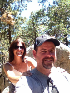
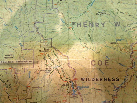
"'If we go for a hike near Tehachapi, we can have lunch at a really good BBQ joint'; that is how I convinced my fella to drive me two hours from Los Angeles to hike up Bear Mountain.  Had I just explained the Bear Mountain project, climbing for Joe, it would have been a no-brainer.  I had called early in the week and was granted a pass by the Bear Valley Springs HOA to check out the area and for me that included a short hike to a peak on behalf of Joe.

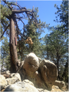
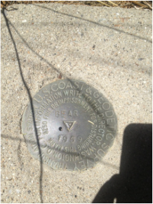
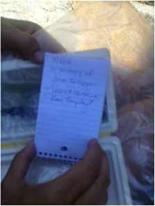
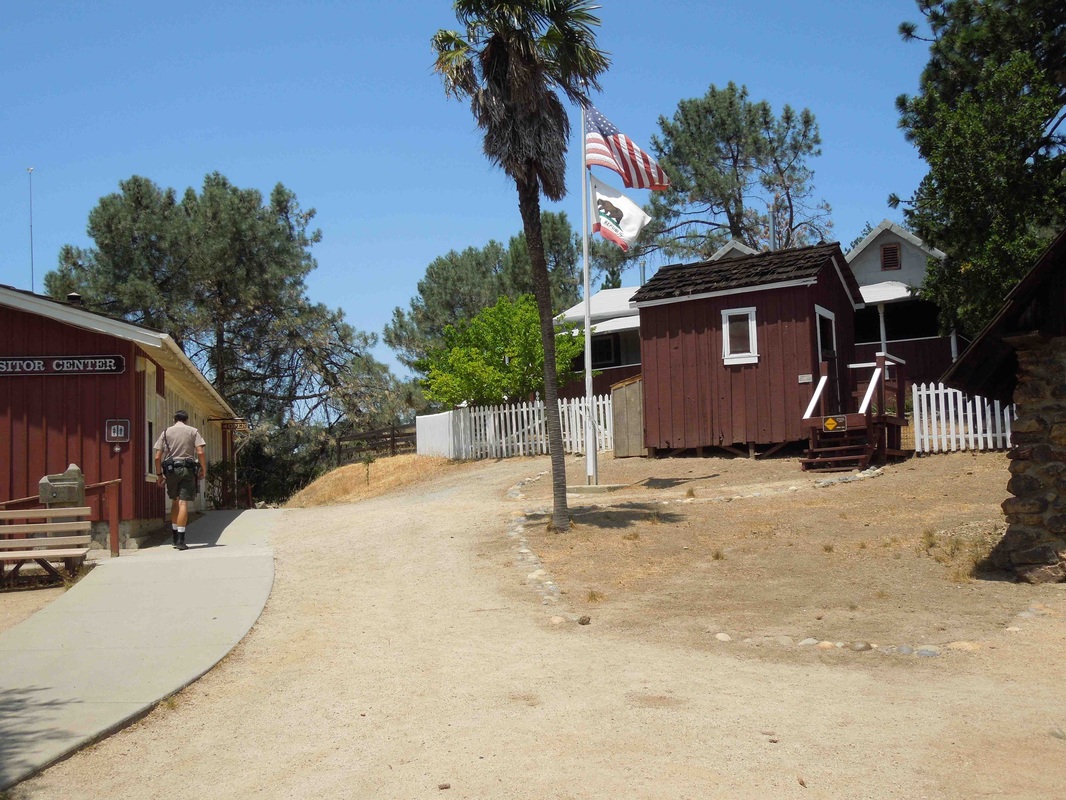
"First stop was lunch at Red House BBQ in Tehachapi.  It did not disappoint and worth a detour on future trips up the 14 and 395 highways.  Then on to visit the Cesar Chavez National Monument in Keene, California, just a short drive down Highway 58.  After a short tour of the museum and grounds we headed over to Bear Valley Springs HOA and picked up a huge packet of maps, information, and properties for sale should we be interested.  We quickly headed up to Paramount Drive and parked at the end of the road, walking back to the intersection of Paramount and Wilderness Drive, where we found an old road heading up.  Following this road we encountered a couple of gates but the road was open and outside of any no-trespassing areas.  It was a short hike to the top, finding a lookout, benchmark and the much sought for summit register.  Joe’s name was signed in and a few pictures taken then time to head home.  One last stop at the Bear Valley Country Club for a drink at the bar to cool off completed the day. 

"I didn’t get a chance to meet Joe on the trails but I have a feeling that I know him and more importantly that I would have liked him.  In true peakbagger fashion, he chose a word that set a goal.  Most of us who hike have similar dreams of completing lists; using it only as an excuse to get outside and appreciate the mountains in all their variety offered.  I am sure that Joe would have enjoyed this outing in its entirety from BBQ to peak."

 
PicturePhoto #1
Fred Feller writes:

"On Saturday, June 29, the hottest day of the year so far in the San Francisco Bay Area, brother Jon and I left the relative cool of Mill Valley and Berkeley for an attempt at Bear Mountain #18 in the wilds of Santa Clara County, east of Silicon Valley.  (See photo #1).  Bear Mountain 18 is located in Henry W. Coe State Park which, considering its proximity to the mega-million population centers of the Bay Area, is amazingly isolated.  Relying on Google Map directions, we chose the northern approach by way of Livermore, where the temperature hit 105 degrees.

"We were using the same route as was attempted by Bill Guilford in a valiant but failed effort on June 17, while brother Guilford was en route to Southern California, after attending the memorial for Joe in Berkeley on June 15.  Guilford had used this route based on my directions and warned me that it appeared to be faulty, but I dismissed this as a result of carelessness on his part, plus the fact that he had only my phoned-in instructions to go by, with no map, no GPS device and a cell phone with no reception.  We were equipped with a detailed map, GPS and compass in addition to the Google route map, which appeared to take us straight to the summit of Bear Mountain. 


PicturePhoto #2
"Nevertheless, Guilford was right.  After a couple of wrong turns and a return to Livermore for more gas, we followed the only road possible until it ended on the slopes of Mount Hamilton, at the famed Lick Observatory (photo #2).  In the Observatory gift shop, there were many maps of the universe and the solar system available but none of the surrounding territory.  However, when I told the saleslady that we were trying to find Henry W. Coe State Park, she cheerfully said: 'Oh you can’t get there from here.'  She told me that the roads on my Google map were private, belonging to ranchers who were serious about their No Trespassing signs and quite likely to take shots at anyone failing to heed their warning.

"Even if we had been tempted to ignore this advice, we confirmed, on our way back to Livermore, that every dirt road leading in the direction we wanted to go was blocked by a locked gate.  In fact, these gates usually had multiple locks on them; we counted eight on one in particular.  Why the need for so many locks I don’t know, but it made the gates look a little like those bridges on the Seine in Paris on which the railings are covered with locks supposedly put there by lovers who have then thrown the keys into the river.


PicturePhoto #3
"On more closely examining my Henry Coe Park map, I noticed that 'No Park Access”'was typed in very small letters next to the illusory road we had been attempting to find.  Brother Jon thought it was rather late in the day (literally) to be making this discovery, but he agreed that, despite our failure to reach Bear Mountain, or even the park in which it is located, it had been a day well spent.  The golden, rolling hills dotted with live oaks we had driven through were a fine sight and we thoroughly enjoyed the visit to the Lick Observatory, which neither of us had ever been to before, nor are we very likely to visit it again, considering its distance from home or from any other attraction.

"Jon had had enough for one weekend, but I was determined to make another attempt, this time from the west.  Sunday morning I headed out in Joe’s Jeep on my own, driving south down Interstate 880 and then California 101, past San Jose to Morgan Hill and then east. A very pleasant 13 mile drive into the hills took me to Coe Ranch Headquarters, where I spoke to several very helpful park rangers.  When I asked whether I could get to Hobbs Road (which on my map leads to Blue Ridge Road and then to  Bear Mountain Road)  from where we were, they said 'sure, are you on foot or on bicycle?'  When I replied that I was in a Jeep, they laughed and told me that vehicles were not allowed in the Park, except for one day a year, in April, by lottery.

"I knew that I was not going to hike the 12 miles from HQ to Bear Mountain that day, in the 100 degree heat, but I asked whether the 24 mile round-trip could be accomplished in one day, if the hiker was in good shape and started early enough.  I was told that it could be done, but that the route was brutal, with an up and down elevation change totaling more than that from Yosemite Valley to the top of Half Dome. I was advised that a 3-day backpacking trip would be the best way to go, preferably in spring.

"So that’s the plan, although brother Jon may go for the one day trek before I get around to the backpacking trip.  Meanwhile, this Bear Mountain can be seen in photo #3, somewhere out there.  Joe’s Jeep is in photo #4 looking wistfully toward the mountains.  Although I never even made it on to the map in photo #1, I enjoyed both day trips and  recommend them to anyone with the time and the inclination to visit either the Lick Observatory or the historical Coe Ranch Headquarters (photo #5), at which I spent a pleasant few minutes.
"


Picture
Photo #4
Picture
Photo #5
 
Laura Newman writes:

"We are going for a leisurely Saturday drive from Los Angeles to Bear Valley Springs this weekend.  I have been granted access to Bear Mountain [#14] via the Homeowners Association....  The peak also happens to be a CaP2K.

I have room in our car for 2 more people if anyone is interested in joining Ken and I.  We will probably leave in the morning, pick up our pass and do the hike following Dennis Poulin's tracks (which happens to be the same MO for getting the access).  It is 2.5 miles RT and 600 ft gain.  The high temperature for the day is 82d.  Lunch likely afterwards in nearby Tehachapi or thereabouts.  It is about a 2 hour drive each way and we need to be back in Los Angeles by 4ish for a poker tournament.

If you are interested in either going with us or meeting nearby and hopping in our car, please reply directly to me....  Happy 4th everyone."
 
Andy Martin writes:

"I've climbed 4 Bear Mountains 'by accident' to date [#21 on 8/1/2003, #14 on 5/11/2004, #3 on 5/21/2007, and #11 on 9/6/2010].  Don't have pics, but could provide route info if needed."